- Mon to Fri: 8 AM - 8 PM | Sat: 9 AM - 1 PM
Kilimanjaro Machame Route 5 Nights / 6 Days
Safari Overview
This is undoubtedly the most beautiful route up Kilimanjaro. All your equipment and supplies are portered and a cook prepares all your meals. Your accommodation on this route will be strictly tents only. This makes Machame (also referred to as the “Whiskey route”) better suited to the slightly more adventurous hiker, however rewarding him with a scenic splendour such as not seen on the Marangu route. From late afternoon sunsets at Shira, to the misty revelations of Kibo at the great Barranco Wall, the Machame route offers the adventurous hiker stunning scenic views over the unending African Landscape.
The Machame route is normally completed in a minimum of 06 days. There is an added benefit to this, as you are afforded the most valuable commodity on the mountain – acclimatisation. The Machame route takes you high to Lava Tower (4630m) on the day 3 and brings you down by nearly 700m for an overnight at Barranco camp (3950m). This is the secret to successful acclimatisation.
Main Highlights
- Scenic Route: Traverse one of Kilimanjaro’s most beautiful paths, offering diverse landscapes.
- Summit Success: High success rates compared to other routes due to its gradual acclimatization profile.
- Camping Adventure: Overnight in campsites along the trail, providing an immersive mountain experience.
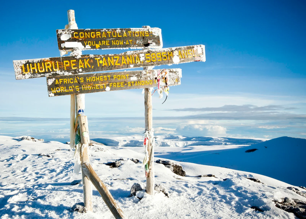
- Uhuru Peak: Reach the highest point in Africa for a truly unforgettable moment.
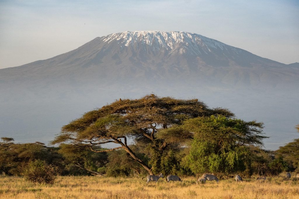
- Wildlife Encounters: Spot unique flora and fauna within Mount Kilimanjaro.
Itinerary - Daily Safari Information
Day 01: Machame Gate (1490m) – Machame camp (2980m)
Hiking time: 7h
Distance: Approximately 18kms
Habitat: Montane forest
Your day starts early with a briefing, followed by breakfast and a 45-minute drive from Moshi (910m) to the Machame village (1490m). The guides and porters prepare and pack the supplies and your equipment in the village. You will receive a lunch pack and you can also purchase supplies in the village. Depending on the condition of the road, it is possible to drive from the village to the Machame gate, but if not, the muddy 3 km walk will take about 1 hour to complete. After registering at the gate office, you start your ascent and enter the rain forest almost immediately. There is a strong possibility of rain in the forest, which will transform the trail into a very soggy, muddy and slippery experience. You will have a welcome lunch stop about half way and will reach the Machame camping area in the late afternoon.
Your porters (arriving at the camp site long before you) will have erected your tent on your arrival. In the evening the porters will boil drinking and washing water and the cook will prepare dinner, before you retire to your tent for the night. Night temperatures can already drop to freezing point at this campsite.
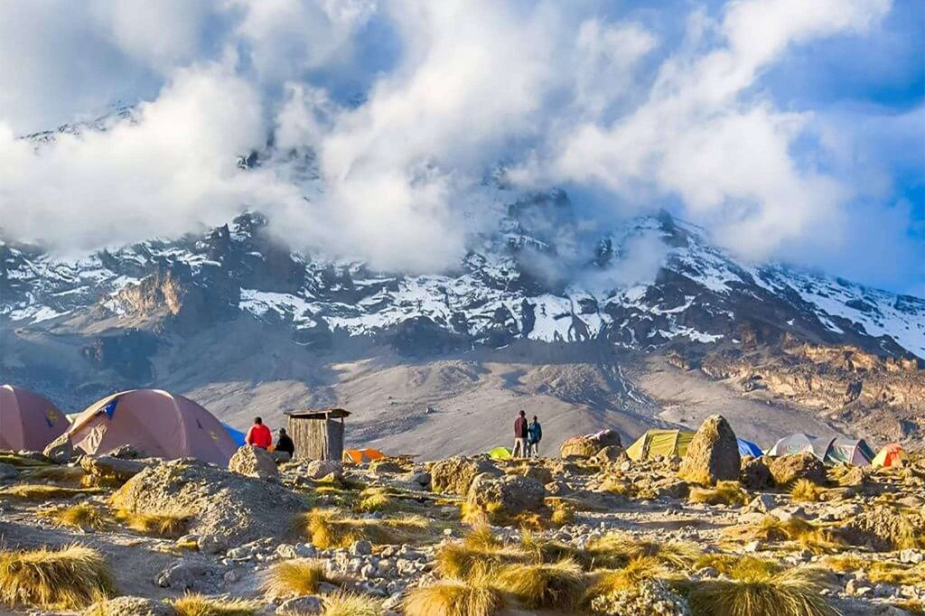
Day 02: Machame camp (2980m) – Shira camp (3840m)
Hiking time: 6h
Distance: Approximately 9 kms
Habitat: Moorland
You rise early at Machame camp and after breakfast you climb an hour or so to the top of the forest and then for 2 hours at a gentler gradient through the moorland zone. After a short lunch and rest, you continue up a rocky ridge onto the Shira plateau. By now you will be able to see in an easterly direction, the Western Breach with its stunning glaciers. You are now due west of Kibo and after a short hike you will reach the Shira campsite at 3 840m. The porters will boil drinking and washing water, before serving dinner. The night at this exposed camp will even be colder than the previous night, with temperatures dropping to well below freezing.
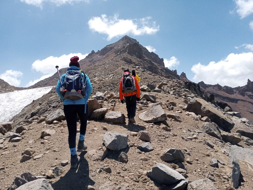
Day 03: Shira (at 3840m) – Lava Tower (at 4630m) – Barranco camp (at 3950m)
Hiking time: 7h
Distance: Approximately 15 kms
Habitat: Semi-desert
The route now turns east into a semi desert and rocky landscape surrounding Lava Tower, where you reach an altitude of 4630m after about a 5 hours walk. Lunch is served in a designated area before ascending the rocky scree path to Lava Tower (4630m). This is definitely the toughest day so far. It is normally around this point, where for the first time, some climbers will start to feel symptoms of breathlessness, irritability and headaches. After lunch you descent again by almost 680m to the Barranco camping area and after reaching the high altitude of 4600m at Lava Tower, the true acclimatisation benefit of this day becomes clear. This descent to Barranco camp takes about 2 hours and offers great opportunities to take some beautiful photographs of the Western Breach and Breach Wall. The camp is situated in a valley below the Breach and Great Barranco Wall, which should provide you with a memorable sunset while you wait for the preparation of your dinner.
Day 04: Barranco camp (3950m) – Barafu camp (4550m)
Hiking time: 7h
Distance: Approximately 13 kms
Habitat: Alpine desert
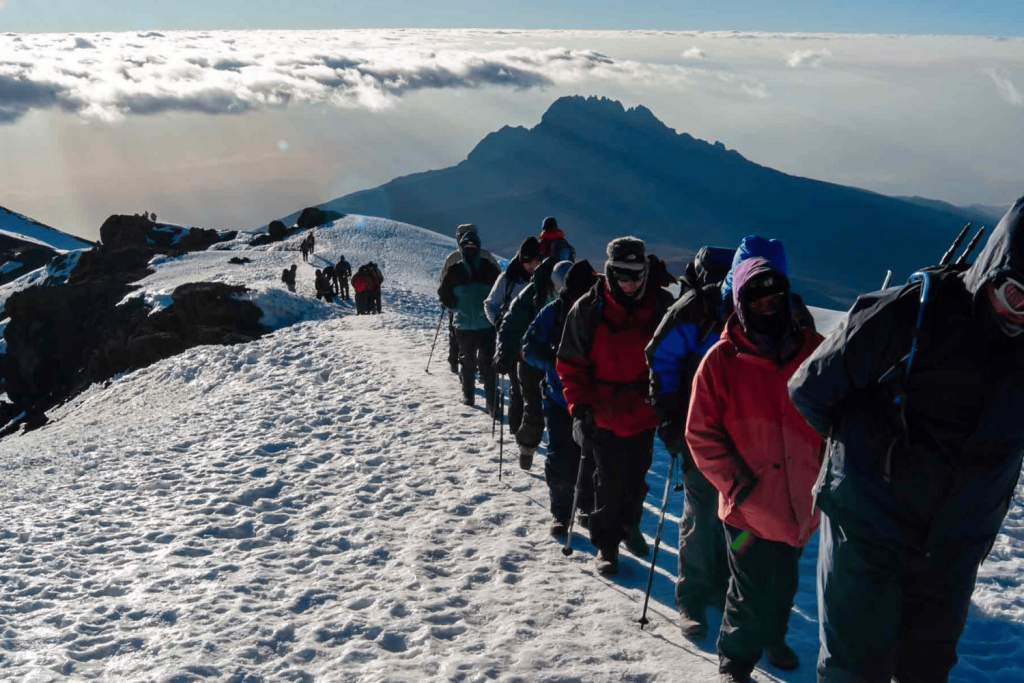
After spending a night at the Great Barranco Wall (a very imposing sight at first), you make your way up this awesome looking obstacle, which in the end normally turns out easier than what you anticipated. Topping out just below the Heim Glacier, you now appreciate just how beautiful Kilimanjaro really is. The route then heads down through the Karanga Valley over intervening ridges and valleys, and then joins up with the Mweka route. This is the preferred route down from the summit, so remember it. Turn left up the ridge and after another hour or so, you reach Barafu Hut.
The last water stop on the route is the Karranga Valley, as there is no water at Barafu camp. Barafu is the Swahili word for “ice” and it is a bleak and inhospitable camping area to spend the night. Totally exposed to the ever-present gales the tents are pitched on a narrow, stony, and dangerous ridge. Make sure that you familiarise yourself with the terrain before dark to avoid any accidents. The summit is now a further 1345m up and you will make the final ascent the same night. Prepare your equipment, ski stick and thermal clothing for your summit attempt. This should include the replacement of your headlamp and camera batteries and make sure you have a spare set available as well. To prevent freezing it will be wise to carry your water in a thermal flask. Go to bed at round about 19h00 and try to get some precious rest and sleep.
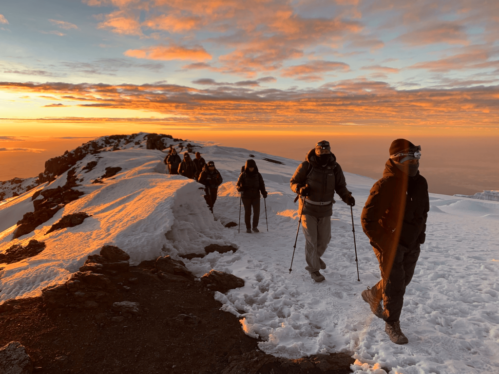
Day 05: (Summit attempt) Barafu camp (4550m) – Uhuru Peak (5895m) – Mweka (3100m)
Hiking time: 8h to reach Uhuru Peak, 7 – 8h to descend to Mweka
Distance: Approximately 7 kms ascent – 23 kms descent
Habitat: Stone screen and ice-capped summit
You will rise around 23h30, and after some tea and biscuits you shuffle off into the night. You will head in a north-westerly direction and ascend through heavy scree towards Stella Point on the crater rim. For many climbers, this 6-hour walk to Stella point is mentally and physically the most challenging on the route. At Stella Point (5685m) you will stop for a short rest and will be rewarded with the most magnificent sunrise you are ever likely to see (weather permitting). From Stella Point you will normally encounter snow all the way on your 2-hour ascent to Uhuru Peak. The time you will spend on the summit will depend on the weather conditions. Do not stop here for too long, as it will be extremely difficult to start again due to cold and fatigue. Enjoy your accomplishment and a day to remember for the rest of your live. The walk back to Barafu from the summit, takes about 3 hours. Here you will have a well earned but short rest and collect the rest of your gear. The route is not difficult and will take you down the rock and scree path into the moorland and eventually into the forest. The camp is situated in the upper forest and mist or rain can be expected in the late afternoon. Dinner and washing water will be prepared.
Day 06: Mweka camp (3100m) – Mweka Gate (1980m)
Hiking time: 3h
Distance: Approximately 15 kms
Habitat: Forest
After an early and well-deserved breakfast, it is a short 3-hour and scenic hike back to the Park gate. At Mweka gate you sign your name and details in a register. This is also where successful climbers receive their summit certificates. Those climbers who reached Uhuru Peak (5895m) receive gold certificates. From the Mweka Gate you will continue down into the Mweka village, normally a muddy 3 km (1 hour) hike. In the Mweka village you will be served a delicious hot lunch!! You now drive back to Moshi or Arusha for your well deserved rest and overnight stay.
- Professional mountain guides, cooks, and porters.
All park fees, including Kilimanjaro National Park entry and camping fees. - Rescue fees and government taxes.
- Camping equipment, including tents and sleeping mats.
- All meals during the climb (breakfast, lunch, and dinner).
- Drinking water and hot drinks.
- Transfers to and from Kilimanjaro National Park.
Oxygen cylinders and first aid kit for emergencies. - Two nights’ accommodation in Moshi (before and after the climb).
- International flights to and from Tanzania.
- Tanzania visa fees.
- Travel insurance (mandatory).
- Personal climbing gear (e.g., hiking boots, sleeping bags, warm clothing).
- Tips for guides, porters, and cooks (recommended).
Snacks, beverages, and other personal expenses.
Additional accommodation or activities outside the itinerary. - Portable toilets (available at an extra cost).
Our Client Testimonials
 End to End Excellence with Heart - I went on my lifelong dream trip to Africa with my brother and four friends in October 2024. I was introduced to Paul at the Travel and Adventure Show... read more in Los Angeles by a friend who is an extensive traveler and a very satisfied customer of African Savannah Holidays. From the moment I met Paul, I knew I would put my dream vacation in his hands.
Working with him could not be easier. He listened carefully to my long “wish list” and my budget considerations; then prepared an itinerary that met every wish with thoughtful care. His communication was always professional, prompt, concise, and friendly.
He met us upon arrival bearing gifts, and provided an orientation of our three weeks in detail. It included Kenya, Amboseli National Park, Lake Manyara, Ngorongoro Crater, Olduvai Gorge, Serengeti, Masai Mara, and finally Zanzibar. Every single aspect of this trip exceeded our expectations: friendly, charming, and informative guides, lodgings that frankly blew me away, food, and the hot air balloon ride. Every day was so exciting and yet, every following day was better than the last.
Our guides knew just where to take us so that we had encounters with four of the Big Five- with the black rhino as the hold out, and we were moved by the experience of being in the wild with all the magnificent animals. At times, we were alone with lions, cubs, cheetahs, leopards, giraffe, baboons, elephants, hippos, and birds we have never seen before! Being there in Africa’s spring meant that we not only saw babies, but it was also not crowded, the temperature was moderate, and there were no mosquitos!
More than the excitement, was a deep sense of the Beautiful. African Savannah Holidays embodied the culture of Africa that values harmony, respect, and love. With them, we brought back something that can’t be captured in pictures. Our goodby to Africa, Paul, and African Savannah Holidays was gratifying, as the six of us made new friends, deepened our friendship, and emblazoned the sights and sounds of Africa forever in our hearts.
If you are considering a trip to Africa, you must find the African Savannah Holidays on line or come meet Paul at the Travel and Adventure Show at the Los Angeles convention Center in February 2025 . Maybe I’ll see you there!

November 17, 2024
Beautiful Samburu, our African Savannah Adventure - We have travelled previously on safari with African Savannah Holidays and this year we chose to visit the semi arid Samburu Region in northern Kenya. We stayed at Ashnil Samburu... read more Camp and at Samburu Intrepids Camp chosing to fly from Wilson Airport in Nairobi in order to avoid a 6 hour road trip into the bush, the flight was just 45 minutes. Camps were very good with a preference for Ashnil and wildlife in Samburu was excellent. Paul Mgubwa is Director, his service was first class, our guide James Maina was excellent, he was a patient driver and had respect for the animals we saw. Our safari overall was a good one, quite hot 32 degrees at times but its a dry heat so was not uncomfortable.
All of our arrangements from meet and greet in Nairobi through to departure was extremely well organised, we had a fabulous safari and felt we were in really good hands throughout. Sincere thanks Paul we would certainly recommend you to friends wishing to try a safari, it was all that we wanted, just perfect.
September 22, 2024
Nairobi National Park - Wonderful experience! We went for a safari in Nairobi National Park. Professional and friendly driver, nothing was too much trouble for him. We were picked up from our accommodation, spent... read more day in national park, had a late lunch and came back to our accommodation. From the start to the end it was a fantastic experience.
September 12, 2024


